Source: JRC, Italy 2001 [ http://gmes.jrc.it/download/Snapshot%20reports/GMES%20Benefits%20Framework.pdf ]
Networks of Excellence: The aim of this proposal is to establish Europe as the International scientific leader in (The scientific fields are clearly defined in the priority areas of Framework 6 (Annex 2 of Call for Expression of Interest)
Integrated Projects (Solving a society problem) The aim of this proposal is to mobilise the European scientific expertise in Dementia to provide health care professionals with relevant, up-to-date information, methods and tools for the diagnosis and treatment of Dementia..
1.1 Contribution to Priority Thematic Area of Framework 6
1.2 Contribution to the European Research Area
2. Background to the Proposed Work
In a context of emerging, knowledge-based economies, Europe has to develop its institutions, which for generations have been maintained by citizens in dialogue with university trained governmental officers and professionals. By 'institutions' is ment not the governing bodies of the EU or other specific organisations, but the rules that enable and constrain human behavior. It is increasingly recognised that institutions influence human use of natural resources (Ceesa, WG A, 2001 [http://www.ceesa.de/ceesa_WGA.html]). Institutions are at the core of the interplay between economic, ecological and social processes, and play an important role for economic growth, ecological sustainabilty and social equity. An institution like property rights is actualized in terms of agreements and deeds, procedures and information systems. The development of institutions is, therefor, closely related with the development of services and infrastructure allowing for information access and use.
In the context of geographic information, the following structure of
information has been identified:
|
|
|
|
|
|
| OrtoImagery ('Landscape')
Selected topographical themes:
|
and other place names) |
|
|
|
An important distinction between the two main data groups is that the objects of the first group are visible: they can be identified by discontinueties in the terrain. The socio-economic units, however, are identified by action of man, in other terms: socially constructed. The former group can be recorded by means of satellite sensors, e.g to produce OrtoImagery, the latter not.
The following table may give a rough idea of the relative importance
of the data groups. It is based on information available through the same
study. The relative weight is based on estimates of cost of production
for original use.
|
|
|
|
|
|
Selected topographical themes:
|
|
|
|
|
The sources do not provide a figure for OrtoImagery, which may contribute to all data groups, and furthermore do not indicate how the cost of geographical data for the construction of roads and buildings is taken into consideration. According to the information available, the relatively largest data group relates to real estate (Units of property rights: 27).
The Priority Thematic Areas of Research in FP6 mentions GMES: global monitoring for environment and security (1.1.4.ii). In order to build up a European capability in the field of monitoring for environment and security, research is requested, among others on the qualification of models combining spatial and terrestrial data in an integrated operational information system.
The Outline GMES EC Action Plan specify the notion of 'spatail and terrestrial
data' as follows:
| "Many observation satellites already exist that are capable of delivering useful data, but continuity of service is not guaranteed and they are primarily (with certain exceptions) designed for scientific purposes. Their integration with terrestrial data infrastructures needs to be strengthened." |
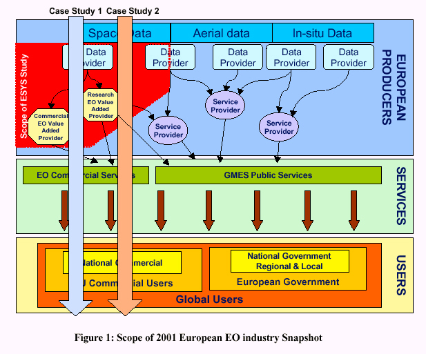
Moreover, the GMES Benefits Framework illustrates the data flow as depicted in the following figure, which relates In-situ Data to Aerial and Space Data. In-situ data may be acquired from ground based sensors, so the role of 'terrestrial data infrastructures' is probably not fully explicitated by that version of the framework.
The Priority Thematic Areas furthermore refers to security and terrestrial data in the context of applied IST research addressing societal challenges (1.1.2.i), including the protection of .. property. Intelligent systems have to be established with defined geographical and functional areas of responsibility, an institutional as much as an engineering challenge.
Supplementing the above references to the FP6 priority areas, mention is made of the recent communication on exploitation of public sector information. The communication considers public sector information a prime content resource, and refers among others to legal information and to geographical information relevant for transport and tourism (cf. the above mentioned data on property rights, and addresses, respectively). An increasing demand for pan-European information products is foreseen. This demand is being substantiated by the European Agreement on a Voluntary Code of Conduct for Pre-contractual Information on Home Loans, signed by the European Mortgage Federation and consumer organisations (EMF, 2001 [http://www.hypo.org/].
Summarising, and following the structure of the GMES Benefits Framework,
it has been demonstrated that socio-economic data plays a substantial role
relative to data on visible terrain objects. European citizens' need of
socio-economic, terrestrial data has been illustrated by referring to protection
of property and home loans, and the provision of such data through public
services has been indicated. The need and context for strengthening integration
of terrestrial data infrastructures with satellite Earth observations has
thus been established.
----------------
Why not use a commercial solution (e.g. products or services on the
market)? Explain why existing products and services are inadequate.
Why now? (and not 5 years ago. Why cant it wait another 5 years?)
Why not transfer technologies or solutions from some other area?
What R&D has been done up to now (key issue here is the fragmentation
of R&D)?
The usual answer here is that the individual areas of expertise exist
but the problem is in integrating these and solving the problem in a coordinated
way.
This should be written in 5 lines. Use facts and figures to support
your arguments
3. Expected Results from the Proposed Work
The results of this project will be is described in the following table: The key point here is to express the results in the words of the user. We provided many examples of these in our course.
Expected Result Users of the Results
4. Activities to Achieve the Proposed Objectives
The work will require two main activities. Integration activities will be needed to integrated the diverse range of skills needed to achieve the objectives of the work. When these skills are integrated joint research activities will be undertaken using the integrated areas of excellence.
4.1 Integration Activities
The integration activities can be summarised as follows: The issues
you could cover here are:
Training for all partners the state of the art of the individual scientific
fields.
Workshops on the definition of the integrated approach, the interfaces
between the different fields, the possible mechanisms which could be used
to interface the different fields and options on how to proceed.
Selection of integration activities (joint training courses, workshops,
electronic communication networks, mobility of personnel, joint studies,
establishment of shared databases, shared websites..)
4.2 Research Activities
The main joint research activities required to achieve
the objectives can be summarised as follows:
Here the focus should be on the new research activities that
could be undertaken by the consortium. The scale of the research should
be beyond any one of the partners.
5. Expertise Needed to Achieve Objectives
5.1 Critical Mass Required + Multidisciplinary Skills
Critical Mass: Networks of Excellence: Here you must show the combination of expertise which is required to establish Europe as the world leader it the proposed scientific field. The critical mass will depend on the level of fragmentation of the research OR the current status of European scientists in this field. For Networks of Excellence this should involve ALL the top European scientists in the filed.
Critical Mass: Integrated Projects: Here you must show the combination of expertise which is required to solve the economic or social problem identified in the objective. Here you must list the different expertise needed and from this you can identify the research groups required.
5.2 Proposed Consortium (Organisation, Background and Role)
If you want to be more precise here you could have three tables : (a) CORE GROUP, (b) ASSISTANTS TO CORE GROUP and (c) PARTNERS PARTICIPATING THROUGH PROJECT CALLS FOR PROPOSALS
Organisation Country Chief Scientist Area of Excellence Role in
Project
1 Hyperion Ltd Ireland Sean McCarthy Training Courses for Research
Managers Training Courses for Integration of Partners
2
3
4
5
6
7
8
9
10
11
12
13
14
15
16
17
18
19
20
21
22
23
24
25
6. Promotion of Results Outside of the Consortium
This is an essential criteria especially for the Networks of Excellence.
The approaches here are:
How the results will be delivered to relevant industry associations,
research associations, specific user groups etc. The mechanisms are the
following: scientific publications, contribution to International Standards,
input to EU and National Policy Committees, input to Educational Courses,
Direct to Users ( workshops targeted at the above associations, web communities
of excellence, email groups, training courses, eLearning initiatives, Guidelines,
Best Practices) and input to Regional Development Organisations e.g. Innovating
Regions of Europe, BICs, IRCs, etc.
7. The Role of SMEs in the Proposed Work
This is a major issue in Framework 6. There are two aspects that must be addressed here. (a) The involvement of SMEs in Networks of Excellence and Integrated Projects and (b) how the results of the work will benefit SMEs.
For Networks of Excellence the focus must be on High Technology, Research Performing SMEs. These include biotechnology companies, IT companies, specialist material companies etc. These people are active researchers and can participate as research partners even in Networks of Excellence.
For Integrated Projects the role of SMEs is easier. Those involved in consortia could be High Technology Research Performers as research partners OR High Technology (no R&D ) as test beds for the results.
8. How the Project will be Managed
Networks of Excellence and Integrated Projects will have three types
of partners.
The Core Group will consist of the main partners in the project.
Assistant Partners will support the Core Groups
Calls for proposals will be launched by the consortium to invite new
members in to undertake specific tasks.
In your Expression of Interest it would help if you could identify
the Core Group.
You will also be expected to have a Governing Council made up of
senior representatives from the Core Group organisations. If you can mention
some of these high level individuals it would be useful.